Final project: The Martian Network
3. System Design: Satellite Constellation
One of the primary objectives of this project is to design a system that will provide 100% coverage at all-times. Since the Martian surface is not plain, on the contrary - it's very diverse, it is going to be very difficult to achieve that (if not impossible), but it will be our goal to come to as close to achieving this feat. The information gathered by the 50 terminals spread around the planet is of vital importance and it should be made sure that the terminals are capable of communicating with the space centers on the Earth that give them guidance and with other terminals on the Martian surface at all times.
Many approaches can be taken to solve this problem. One could, for instance, employ a network of low martian orbit (LMO) satellites. They could provide global coverage at all times, including the pole regions. Also, their orbits would be very low at around 1000 km above the Martian surface, so the terminals would be able to communicate with them at much lower transmit powers. However, for global coverage at all times under a reasonable minimum elevation angle (say, 10 degrees) a large number of LMO satellites would be needed (30 or more) and that would amount to gigantic implementation cost of the system. Alternatively, one could employ medium mars orbit (MMO) satellites, however in these case 10 or more satellites would have to be employed.
The simplest solution to the problem seems to be in area stationary satellites (ASS), which are the equivalent to geo-synchronous (GEO) satellites on Earth. For a satellite to area stationary it has have an equatorial orbit 20427 kilometers from the center of Mars. Thus, it has to be at an altitude of 17030 kilometers from the Martian surface. Only three such satellites would be needed to ensure a pretty good coverage and at least one of them would always have a line-of-sight with the Earth. We decided that such a system would not be satisfactory for the following reasons. The elevation angles to these satellites would be very low at high latitudes on the Martian surface, while most of the areas around the north and south pole would not be covered at all. Moreover, since the terrain on Mars is not plain and the satellites are seen only at very low elevation angles at higher latitudes, the ground terminals would often not be able to see the satellites due to obstacles like hills, valleys, etc., which would result in a loss of a communication link. To combat these problems we decided to add 3 satellites at the same altitude, traveling on the polar orbit, to ensure better coverage at higher latitudes.
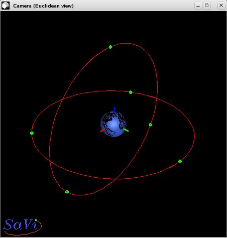
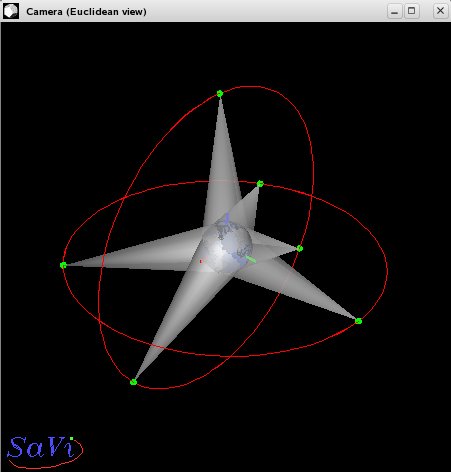
The two figures below show the envisioned constellation:
The figure on the left hand side shows two planes in which the
satellites orbit Mars: the equatorial and the polar plane - each of them
containing 3 satellites. On the other side we see how these satellites
cover the surface of Mars with their antennas. If they are to provide coverage
at the minimal elevation angle of 10 degrees the half-bandwidth angle of their
antennas has to be at least 9.4400 degrees (see
Pratt et al. - pages 406, 432). The above figures were obtained with the help of a
wonderful software called "Savi" that was made specifically for researching the
coverage of various satellite constellations and can be found
here.
Originally, this software was written for planet Earth, therefore a potential
user has to change some parameters and recompile the source code if it is to be
used for planet Mars. The following figure, also obtained by Savi, shows a
detailed analysis of the coverage provided by our constellation.
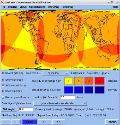
To help the reader visualize the situation better, a map of the Earth was added to provide a better sense of orientation, but the simulation was run with the parameters for planet Mars. It can be seen that global coverage is provided at all times. Even more, in most areas 2, 3, and sometimes even 4 satellites can be seen directly with the minimum elevation angle of 10 degrees. That provides the terminals with some flexibility in case it is on a hilly terrain, where the direct line-of-sight to some satellites is obstructed.
We also ran some simulations with the system of 3 ASS satellites and the results can be seen here.