Results
Step 1:
Below is a plot of the received frequency versus time (Figure 2). This is the
raw data from which we had to determine the EPIRB location.
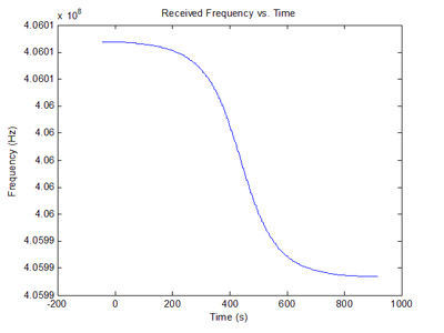
Figure 2: Received Frequency.
Figure 3 shows the true derivative of the raw data. Due to severe quantization
noise, no useful information could be gathered from this plot. Therefore,
another solution had to be found in order to determine the location.
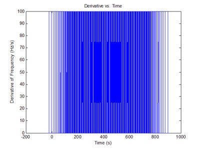
Figure 3: Derivative of Raw Data.
Figure 4 shows the solution to the quantization problem. The original data
was sampled once every fifty time steps to generate a smoother derivative.
This provides a useful maximum to use in later calculations.
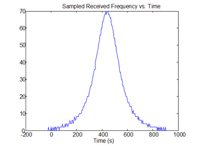
Figure 4: Derivative of Quantized Data.
From Figure 4 it was determined that the maximum derivative occurred at 425
seconds after the satellites crossed the equator. Multiplied by the
latitudinal velocity of the SARSAT satellite, the latitude of the EPIRB was
found to be 25.6473 degrees.
Step 2:
Figure 5 plots received frequencies for 41 known locations of the EPIRB at
latitude 25.6473 degrees. These known locations range from 0 Km (directly below
the satellite) to 2000 Km in increments of 50 Km. The curve with the sharpest
drop-off represents 0 Km and the curve with the shallowest drop-off represents
2000 Km, respectively.

Figure 5: Received Frequency of Many Distances.
Figure 6 shows the derivatives of the received frequencies for the known locations.
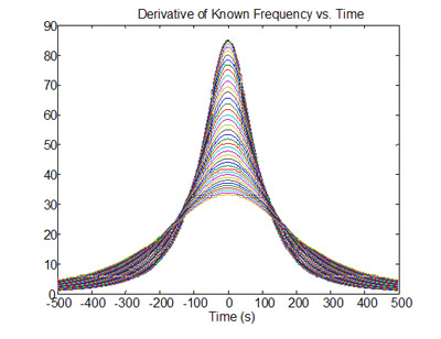
Figure 6: Derivatives of Many Distances.
Step 3:
Comparing Figure 6 to Figure 4, it was determined that the actual EPIRB fell
between curves of 600 Km and 650 Km. Referencing to Figure 7, we averaged the
amplitude per unit distance at these two values to determine the linear conversion
factor between maximum amplitude and distance.

Figure 7: Relationship of Derivative and Distance.
The linear conversion factor in the above range was determined to be 0.0384 Hz/s*Km.
Multiplying by the maximum derivative from Figure 4, a longitude east of the
satellite and a longitude west of the satellite were calculated. The two possible
longitudes are -79.4849 degrees (West Solution) and -72.0679 degrees (East Solution).
Contextual data, provided by Flight Controller Durgin, was utilized to
determine the final longitude of the EPIRB was -79.9321 degrees. The final
coordinates are (25.6473, -79.4849). This location provided by Google Maps is
shown in Figure 8.

Figure 8: Bimini Island
|