|
Project Description
As
a leader in electromagnetic
propagation modeling, Dekalb
Telecom receives
many projects that require
accurate propagation modeling.
One such case that Dekalb
Telecom’s participated in was from the Georgia DA
office to solve a high profile political murder.
The project was setup as a
competition divided into two
phases to narrow the number of
firms involved in the final
project. Phase 1 was a
demonstration of our propagation
modeling technology to narrow
down the participating firms
based on the accuracy of our
propagation modeling. The
Georgia DA provided us with
geographical information and a
few of
received power measurements so
that our model could estimate
the path-loss effects of
terrain, roads, buildings, etc.
Once our propagation model
determined the path-loss
exponents, our model was tested
by the Georgia DA by testing our
model on four locations. The
estimates from this test would
then be compared to actual
measured values. The firms
producing the most accurate
propagation models would advance
onto phase 2 of the competition.
Phase 2 would involve work on
the actual murder case. Since
the Georgia DA subpoenaed the
cell phone records of the
primary subjects, it was our job
to predict the probability that
the subjects were near the
vicinity of the victim during
the time of the murder and that
both subjects were involved in
the murder. The firm that
produces the most accurate phase
2 analysis would be awarded the
contract for the project.
Phase 1 Details
For phase 1, the Georgia DA
provided us with data about the
received power in different
locations, clutter data,
elevation data and the base
station specifications, such as
its azimuth, EIRP, transmitter
location, frequency, scaling
factor and height. This data was
then inserted into our
propagation model which utilizes
free space attenuation, clutter
diffraction and terrain diffraction
theories to estimate path-loss
exponents that can later be used
to estimate signal strength at
any point on the map. For more
information on our propagation
modeling technology, please look
at our
Technology page. For the results from our propagation modeling, please look at our
Technology
Demonstration page.
Phase 2 Details
In
November 2000, a new sheriff was
elected and was murdered one
month later. Police believe that
the incumbent sheriff was
involved in the murder and
identify Patrick C and Paul
S as the primary suspects.
Please view the
Police Report for more
information about the case. Both
subjects work for Burger King,
shown as a flag on Figure 1, and
they both claim to be working
all night.
Since the police department
subpoenaed the cell phone
records of each suspect, we know
which cell towers handled each
of the suspects’ calls at
specific times. The cell towers
involved with handling the
suspects’ calls the day of the
murder are shown in Figure 1.

Figure 1. Cell
towers that handled the
suspects' calls the night of the
murder.
Since cell phone antennas serve
120° sectors and have a maximum
range of a 3-mile radius, as
plotted on Figure 1, the general
vicinity of the suspects can be
located at specific times. These
are "best" case specifications
and most cell phone towers have
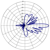
a less ideal range. Figure 2 shows
the antenna coverage pattern for
the
Allgon 7184.15 cell phone
tower used for towers 214, 222,
223, and 224.
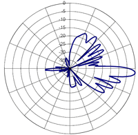
Figure 3 shows the antenna
coverage pattern for the
Allgon
7184.13 cell phone tower used
for tower 041.
Since the maximum range
of the antenna is 3 miles,
Figures 2 and 3 show that this
range is achieved only in the
center of the antenna's sector,
and the range drops off
off-center. This helps to show
that our approximation in Figure
1 is a "best" case approximation
and can place the subjects in
near the cell phone towers with
high certainty.

|
 |
|
Figure 2.
Allgon 7184.15 Coverage
Range. |
Figure 3.
Allgon 7184.13 Coverage
Range. |
The location of the subjects was
further reduced, as shown in
Figure 1, by an estimation of
which roads the subjects likely
were travelling on and by the
areas of interest to the case.
Using such techniques to narrow
the possible location of the
subjects' at specific times,
Figure 1 shows the most likely
location of the subjects shaded
in different colors.
As
can be seen in Figure 1, the
suspects’ cell phone records
clearly
contradict their claim that they
were at Burger King all night.
In addition, our analysis shows
that both suspects were within a
1 mile radius of the victims
home between approximately 8 PM
and 9 PM. Police testing using
an actual cell phone also
confirms that tower 214 does
handle calls from the victim's
home. The police believe that
the suspects were snooping
around the victim's home during
this time. Our analysis also
shows that the subjects were
most likely at Burger King
between 9 PM and 10 PM. Of most
interest to the case is that Mr. S was in the blue shaded
area in Figure 1 at 10:44 PM and
Mr. C was there 10:30 PM and
12:01 AM. The victim's home is
separated from the blue shaded
area by approximately 5 miles
and 10 minutes, with the
assumption that the suspects
were at the furthest point away
from the victim's home within
the reach of tower 222. According to our
analysis, it is
plausible that Mr. C could
have left the blue shaded area,
arrived at the victims home,
committed the murder and
returned back to the blue shaded
area between 10:30 PM and 12:01
AM. It is also plausible that
Mr. S left the shaded blue
area at 10:44 PM and made it to
the victim's house before 11:19
PM, the approximate time of the
murder.
|
